In Depth of CIA’s Report on American-‘Israeli’ Geographic Perspective on South Lebanon Border
CIA’s Report made in January 1986, and became available to be published in 2011.
The Central Intelligence Agency’s [CIA] report on the decision regarding the occupied southern Lebanon border was made in January 1986, and became available to be published in 2011.
Access to many pages of the recently circulated sanitized copy of the report was denied from the source, as the CIA still considers ‘sensitive.’
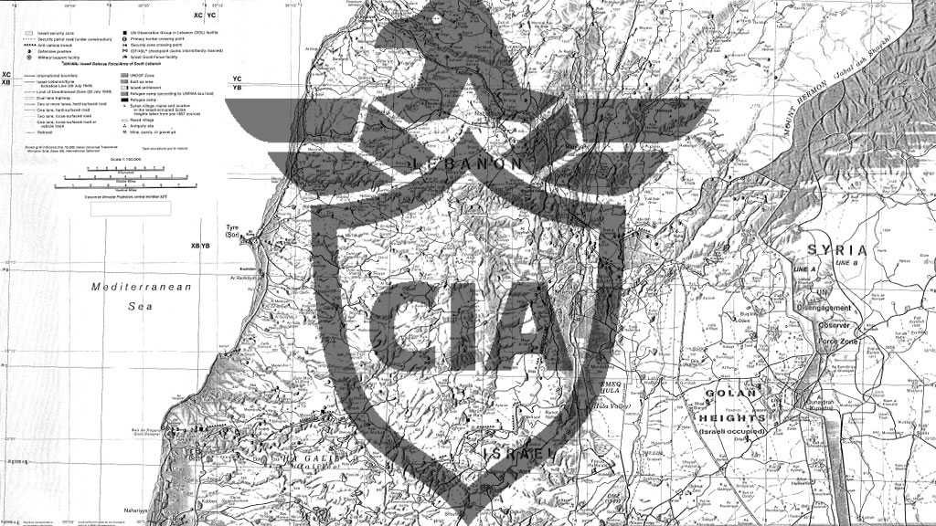
‘Israel’s’ ‘Security Zone’, a buffer that runs from the coast to the Golan Heights and extends 5 to 20 kilometers into Lebanon, is the subject of this research paper. The entire explanation circulates around it.
Excerpt from the report as shown as the following:
The ‘security zone’ covers about 800 square kilometers, nearly half of Lebanon south of Sidon. Long neglected by Lebanon’s central government, the south’s poor agrarian economy has been further disrupted by the 1982 invasion and its aftermath. About 1 10,000 of the approximately 250,000 residents in the south live in the ‘security zone’, according to ‘Israeli’ press reporting. Nearly half of the 1 10,000 are Shiite, although there are areas of although there are areas of Christian, Sunni, and Druze concentrations, according to the CIA paper.
The report, which states that Palestinians were the main target of the ‘Israeli’ 1978 and 1982 invasions of Lebanon, explains how the ‘Israeli’ occupation forces began construction activities within its much-needed ‘security zone’ almost immediately following its 1978 invasion.
Since 1982, the predominant changes have involved improving and building new access and border patrol roads, adding and repositioning fixed ‘defensive’ and observation positions, and building new military support facilities. At the southern edge of the security zone, along the 1949 Armistice Demarcation Line, the ‘Israelis’ are building up their border security strip, which includes concertina wire, a security fence, a dragged strip—bare earth groomed to reveal the tracks of intruders—and a patrol road. In several places the border security strip crosses into Lebanese territory to take advantage of favorable terrain or to create a buffer near ‘Israeli’ settlements.
“Tel Aviv is aware that the ‘Israeli’ occupation further radicalizes this religiously diverse area [Lebanon] and contributes to its chronic instability,” the report admits.
If ‘Israel’ eventually makes a “final” withdrawal, the ‘defensive’ role of the border security strip will become more important, the report adds. “Although the threat of retaliation for any cross-border ‘attacks’ and possible assurances from Lebanese leaders and Syria would be important considerations in ‘Israel’s’ post withdrawal ‘defensive’ policy.”
The present ‘Israeli’-created ‘security zone’ in southern Lebanon owes its existence to ‘Israel’s’ desire for a secure northern border and has evolved from the security arrangements ‘Israel’ established following its 1978 invasion of Lebanon.
Today, an assortment of groups willing to engage ‘Israel’ in limited military encounters operate in and through southern Lebanon…To reach the ‘Israeli’ border, or to maximize their prospects of hitting ‘Israel’ with rockets, these groups must infiltrate through the United Nations Interim Force in Lebanon [UNIFIL] area of operation—not a difficult task in the ‘Israeli’ view—and the ‘Israeli’ security zone.
This research paper analyzes the transportation network, water resources, and population makeup in the security zone and the changes that have occurred in the local economy and are occurring in the ‘Israeli’ infrastructure within the security zone and along the border.
Translation
في العمق: تقرير وكالة المخابرات المركزية حول المنظور الجغرافي الأمريكي “الإسرائيلي” على حدود جنوب لبنان
تقرير وكالة الاستخبارات المركزية حول القرار المتعلق بالحدود المحتلة في جنوب لبنان تم في يناير/كانون الثاني 1986، وأصبح متاحاً للنشر في عام 2011.
وقد تم رفض الوصول إلى العديد من صفحات النسخة المطهرة من التقرير التي تم تعميمها مؤخرًا من المصدر، حيث لا تزال وكالة الاستخبارات المركزية تعتبرها “حساسة”.
“المنطقة الأمنية” الإسرائيلية، وهي منطقة عازلة تمتد من الساحل إلى مرتفعات الجولان وتمتد من 5 إلى 20 كيلومترا في لبنان، هي موضوع هذه الورقة البحثية. التفسير بأكمله يدور حوله.
مقتطف من التقرير كما هو مبين على النحو التالي:
وتغطي “المنطقة الأمنية” حوالي 800 كيلومترمربع، أي ما يقرب من نصف مساحة لبنان جنوب صيدا. وقد تعرض الاقتصاد الزراعي الفقير في الجنوب، الذي أهمله طويلاً من قبل الحكومة المركزية اللبنانية، إلى مزيد من الاضطراب بسبب غزو عام 1982 وما تلاه. ويعيش نحو 10 آلاف شخص من سكان الجنوب البالغ عددهم نحو 250 ألف نسمة في ‘المنطقة الأمنية’، بحسب تقارير صحافية ‘إسرائيلية’. ووفقاً لورقة وكالة الاستخبارات المركزية الأميركية (سي آي إيه) فإن ما يقرب من نصف الـ 10 آلاف من الشيعة هم من الشيعة، على الرغم من وجود مناطق على الرغم من وجود مناطق تمركز مسيحية وسنية ودروزية.
ويوضح التقرير، الذي يذكر أن الفلسطينيين كانوا الهدف الرئيسي لغزو لبنان “الإسرائيلي” في عام 1978 و1982، كيف بدأت قوات الاحتلال “الإسرائيلية” أنشطة البناء داخل “المنطقة الأمنية” التي تشتد الحاجة إليها بعد غزوها عام 1978.
ومنذ عام 1982، شملت التغييرات الرئيسية تحسين وبناء طرق جديدة للوصول ودوريات الحدود، وإضافة مواقع “دفاعية” ومراقبة ثابتة وإعادة تحديد مواقعها، وبناء مرافق دعم عسكرية جديدة. على الحافة الجنوبية للمنطقة الأمنية، على طول خط الهدنة عام 1949، يقوم “الإسرائيليون” ببناء شريط أمن الحدود، الذي يشمل سلك كونسيرتينا، وسور أمني، وشريط جرّ – أرض عارية تم إعدادها للكشف عن مسارات الدخلاء – وطريق دورية. في عدة أماكن يعبر الشريط الأمني الحدودي إلى الأراضي اللبنانية للاستفادة من التضاريس المواتية أو لإنشاء حاجز بالقرب من المستوطنات “الإسرائيلية”.
ويعترف التقرير بأن “تل أبيب تدرك أن الاحتلال الإسرائيلي يزيد من تطرف هذه المنطقة [اللبنانية] المتنوعة دينياً ويساهم في عدم استقرارها المزمن”.
ويضيف التقرير أنه إذا ما تم انسحاب “إسرائيل” “النهائي”، فإن الدور “الدفاعي” لشريط أمن الحدود سيصبح أكثر أهمية. “على الرغم من أن التهديد بالانتقام من أيهجمات عبر الحدود والتأكيدات المحتملة من القادة اللبنانيين وسوريا سيكونان اعتبارات مهمة في سياسة “إسرائيل” “الدفاعية” بعد الانسحاب”.
إن “المنطقة الأمنية” الحالية التي أنشأتها إسرائيل في جنوب لبنان تدين بوجودها لرغبة “إسرائيل” في تأمين الحدود الشمالية، وقد تطورت من الترتيبات الأمنية “الإسرائيلية” التي أنشئت في أعقاب غزوها للبنان عام 1978.
واليوم، تعمل مجموعة متنوعة من الجماعات الراغبة في الاشتباك مع “إسرائيل” في مواجهات عسكرية محدودة في جنوب لبنان وعبره… للوصول إلى الحدود “الإسرائيلية”، أو لتعظيم احتمالات ضرب “إسرائيل” بالصواريخ، يجب أن تتسلل هذه الجماعات عبر منطقة عمليات قوة الأمم المتحدة المؤقتة في لبنان ،وهي مهمة ليست صعبة في نظر “إسرائيل” والمنطقة الأمنية “الإسرائيلية”.
يحلل هذا البحث شبكة النقل والموارد المائية والتركيبة السكانية في المنطقة الأمنية والتغيرات التي حدثت في الاقتصاد المحلي، وتحدث في البنية التحتية “الإسرائيلية” داخل المنطقة الأمنية وعلى طول الحدود.


No comments:
Post a Comment